Mapping Fallen London - Spoilers of a Sort

Because even in 1860, the British Museum was a going concern that would have been a lot less pathetic than the sad little display that the Museum of Mistakes is supposed to be.

I’m quite willing to believe that the Museum of Mistakes is modeled on something specific, but not that one.

That makes sense. I do wonder what happened to it though, especially considering its collection of Egyptian artifacts.

Edit: Is there a thread for matching Surface locations to Neath equivalents, in the opposite way of this one?
edited by evapillar on 11/25/2017

I’d like to add that Lusitania Row may have been [b]edit [/b]Piccadilly. Given that the Shuttered Palace was Kensington Palace, the Jekyll Gardens were Hyde Park, and that this journal snippet states [quote=]Lusitania Row is within sight of the Shuttered Palace.[/quote] I’d say I’m pretty sure of it at this point.

I found a discussion from earlier in the year about the new Mysteries tab questions on the Bay12 forums. Bay12 is responsible for Dwarf Fortress - I found it very fitting to pull that up from there. Piccadilly Arcade was suggested for the Lusitania Row question because Piccadilly Arcade was originally named Portugal Street in 1663. Portugal contained, in antiquity, an Iberian Roman province called Lusitania.

Edited: I changed Piccadilly Arcade to Piccadilly at the suggestion of genesis, below. It fits if FBG still uses the warped geography. Weren’t Jekyll Gardens and the Shuttered Palace rotated 180-degrees or something really odd?
edited by Stygota on 12/5/2017

Piccadilly Arcade is more of a building than a street and is adjacent to Piccadilly. It is Piccadilly itself that used to be called Portugal Street, not the shopping arcade which wasn’t even open till 1909 according to Wikipedia.

Also neither Picadilly itself nor the Arcade are anywhere near Kensington Palace. I suspect this snippet goes back to the days of Alexis when London landmarks were not only renamed but also physically warped. I feel more recently FBG have abandoned that aspect of the lore

Piccadilly ends at Hyde Park Corner, where there is a monumental entrance to said park. I don’t know how much closer you want to get to Kensington. Given the warping effects of the Fall and the general lack of trees these days, I see no difficulties in an observer at that end of Jekyll Gardens seeing the Palace, or of someone from the Palace seeing them. Indeed, if we wanted to baselessly speculate, Piccadilly leads into Knightsbridge which leads into Kensington High Street; it is not entirely without the realm of possibility that all three of these streets could be considered one under the Bazaar’s cartography, which would make Lusitania Row practically go through the Empress’s back bathtub.

Hyde Park is about two miles long and Kensington Palace is on the opposite side from Hyde Park Corner. You physically cannot see the Palace from Hyde Park corner, both because of the distance but also because the park is not a field. There are trees etc in the way (also: “the general lack of trees these days” are you referring to 2017? There are plenty of trees.). And that’s assuming you are at Hyde Park Corner - any further along actual Piccadilly and you also have manor houses in the way of the line of sight.

Anyway, all I was saying was that specific snippet cannot be taken literally. Lusitania Row is Piccadilly as far as I am concerned, just not due to the alleged proximity to the Shuttered Palace.

[quote=genesis]Hyde Park is about two miles long and Kensington Palace is on the opposite side from Hyde Park Corner. You physically cannot see the Palace from Hyde Park corner, both because of the distance but also because the park is not a field. There are trees etc in the way (also: &quotthe general lack of trees these days&quot are you referring to 2017? There are plenty of trees.). And that’s assuming you are at Hyde Park Corner - any further along actual Piccadilly and you also have manor houses in the way of the line of sight.

Anyway, all I was saying was that specific snippet cannot be taken literally. Lusitania Row is Piccadilly as far as I am concerned, just not due to the alleged proximity to the Shuttered Palace.[/quote]
I think it can.

First, as you yourself pointed out, the Bazaar twisted London’s map in an undescribed fashion. We have no reason to assume that Lusitania Row is as straight as Piccadilly, nor that Jekyll Gardens is quite so large as Hyde Park. All estimates based on the geography of Surface London are by nature nothing more than educated guesses.

Second, as to distance, from the front door of Kensington Palace to the Wellington Arch (which is as close to the end of Piccadilly as no matter) is slightly over one mile as the bat flies, if one can trust satellite imagery. One mile, or two or three or four, is easily within visual distance, given good conditions and unobstructed ground. The elevated level of most Palace apartments works in one’s favor.

Third, as to obstructions, I was referring to trees in 1895. We have ample evidence that most of London’s trees were lost after the Fall, leaving those that weren’t cleared for firewood or building material as mere leafless skeletons. Leafless skeletons do a poor job of blocking vision, especially from an elevated position; this is amply demonstrable at this time of year. Furthermore, the change from &quotHyde Park&quot to &quotJekyll Garden&quot implies considerably fewer trees; one can have whole copses in a park, but a garden is generally open.

Fourth, as to good conditions, the tree-murdering darkness precludes normal vision. However, London is amply provided with gaslight, and artificial light, naturally, shines brightest in darkness. In a normal night without dust, fog, or precipitation, a flashlight or campfire can be seen for miles; in the utter darkness of the Neath, an observer on one of the city’s high points (St. Fiacre’s, the Observatory, and certainly the Bazaar’s Spires) should be able to make out with a spyglass any point in greater London.

Thus we can conclude that, without significant tree cover to block the way, not just Hyde Corner but most all of Piccadilly is within visual range of the Shuttered Palace. The only insoluble factor is building height. Sufficiently tall constructions will, of course, blot out anything, and the buildings on the Hyde end of Piccadilly are six or seven stories tall, that is to say, several stories taller than Kensington Palace. When were these built? I don’t know, although the architectural survey of London is available online if anyone’s more curious and has more free time than I. Even if they were around when London fell, did they survive the Fall? Uncertain. Since the only complicating factor is basically up to Failbetter, I think it’s fair to trust them when they say that you can see Lusitania Row from the Palace.

(Besides, even if all those buildings are still there, I think seeing building fronting Lusitania Row counts as seeing Lusitania Row.)

Unless of course we’ve all been mistaken this whole time and the Shuttered Palace is Buckingham or St. James’s, both of which would have much better views of Piccadilly. I don’t think that’s possible, however.
edited by Siankan on 12/5/2017
Additional note:

When Alexis popped in at the beginning of this thread to confirm that Buckingham is not the Shuttered Palace, there were some statements about the Palace now being on the east side of Jekyll Gardens (which led to confusion, though of course everyone came to Kensington at the end). Does anyone remember when this was mentioned and where?

Anyway, if the Shuttered Palace has relocated to the other end of Hyde Park, I don’t think we have any more doubts about it being close enough to see Lusitania Row.

I’ve just found this super cool tool comparing modern London with Victorian-era maps and thought this would be a good place to share it!

[quote=TheLimey][quote=Richard ]Geography alert! If you have a Noman and the right Ambition, you get this:

&quotAn annex of the Bazaar extends past the cathedral to the rusting shadows of Beazley’s Gate&quot

Since we know the Bazaar is at Borough Market, the cathedral’s just Southwark Cathedral - no mystery there.

Beazley’s Gate? No idea. I don’t know that part of London at all well, so there might be some obvious analogue. Or, fancifully, perhaps it’s an homage to Joseph Bazalgette…[/quote]

I wonder if it’s a subtle nod to Michael Moorcock. He has a Bishop Beesley in the ‘Jerry Cornelius’ stories, which could make it Bishopsgate…[/quote]The now-retired Amber Eyes Particular Day refers to Beazley’s Gate as &quot…choked and rusty rubble, haunted by the ghosts of its departed trains.&quot

I don’t know enough to be able to use this information personally, but I’m sure ‘this is a (run-down) train station’ probably eliminates some chuck of possible locations.
edited by Vavakx Nonexus on 1/25/2018

One possible candidate for Beazley’s Gate would be New Cross Gate, which was a major railway terminus in mid 19th century, is located in Bermondsey and is a sight of a former abandoned rail station. New Cross Gate was named for a tollgate. I can imagine how it could have become “Bermondsey Toll Gate” and then “Beazley’s Gate”. Maybe.

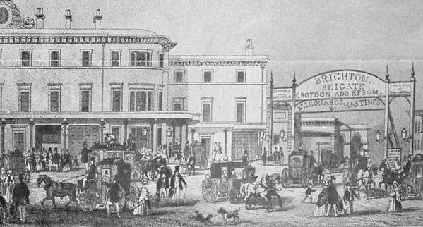
Aha! That’s the link: trains. Beazley was a real person: Samuel Beazley, architect and comic playwright. Because of the connection between his name and the rough location of Beazley’s Gate, I reckon it could be London Bridge Station, which he was engaged to remodel, and in 1862 was still adorned with a cast-iron entrance (I’m none too sure he personally designed it, though):

Then as now, the station served the South East: the gate mentions Brighton, Reigate, Croydon and Epsom, St. Leonards and Hastings. Since few of those places were close enough to London to accompany her to the Neath (I’m not going to speculate on the fate of Croydon), and Fallen London is now more or less coastal, the station would presumably have no post-lapsarian purpose.

That seems pretty definite evidence to me.

New Cross Gate is a fair way further along the A2 road from (South) Bermondsey and though there was a depot alongside it, it was not, I believe a terminus, being too far out. According to the linked article by the Telegraph Hill Society, the station is &quotlittle changed from when it was originally built&quot – though that may only refer to the street-side station building. The area was originally known as Hatcham, which was a village to the north of Telegraph Hill.

http://thehill.org.uk/society/New_Cross_Gate.htm

Not a terminus, you are right. But a major junction and, more significantly, the very first rail station.

But yes, it is slightly too far out and in terms of significant landmarks London Bridge makes a lot more sense. The reason I am not wholly on board with that yet is because of the quote above giving a sense that it’s an abandoned station which London Bridge most certainly wasn’t. On the other hand it may have become abandoned post-fall which then makes London Bridge a strong contender.

London Bridge also had a defensive gate house but that wasn’t part of the station. I guess Beazley’s Gate could then be just a general amalgamation of the former London Bridge infrastructure.

Don’t forget that (as Vexpont pointed out), London Bridge Station doesn’t have anywhere to service. I don’t know of anything below Southwark that’s been definitely confirmed to have been on this side of the seashore. The only things in that direction are glim-collectors, the distant lights of the Archipelago, and lots of PCs living in giant shells and decommissioned steamers. Given that, it’s entirely logical for London Bridge Station to have been abandoned; presenting it as a piece of rust is an evocative touch.

Also, given the geography of the quote that started this discussion, we must look for Beazley’s Gate either north of Borough Market (passing Southwark Cathedral on the right) or east of it (passing the Cathedral on the left). There’s nothing significant north of the Market. East of it, however, almost as soon as you pass the Cathedral, you’ll run straight into London Bridge Station. Its geographical position fits the quoted text beautifully.

Fellow forumite Elderfleur posted this large version of the new Fallen London map on one of the Website Redesign threads. Besides being a really nice map, it includes some street names. I am not sure if any of the information on it is new, but it seems appropiate to have it linked in this thread.

Oh, now I agree Wilmot’s End should be Primrose Hill. The Vicar of Wakefield knows that.

Where is Flute Street?

[quote=MrCandles]Where is Flute Street?[/quote]Flute Street likely doesn’t correspond to any real-life London location (it’s beneath the Neath, after all), and it’s likely been here for a few cities now.